Show Posts

This section allows you to view all posts made by this member. Note that you can only see posts made in areas you currently have access to.


Messages - tetris42

Pages: [1]
1
Map Requests / Re: Anyone want to help stitch a map together?
« on: June 18, 2012, 07:19:45 am »
Hey, I checked the PNG and unfortunately your image doesn't align with the rest of the map, I had to go in and do it over again manually.  I think whatever automation technique you use probably won't well for this particular map.  Thanks anyway.

2
Grizzly: It might be.  The camera controls in flyby mode have a maximum height as it is, however I think that's parallel to the driver's height and probably not a specific number (not sure though).  Unfortunately I'm not even sure the camera will tilt down to an isometric angle, so it really does sound like that should be the next thing I should look into.  I'll post back if I can get that modified at all.

3
If you manage to change the camera angle, remember that perspective will still distort the map a little. Stitching screenshots of a hill or mountain will get a bit tricky in that they will not line up perfectly with one another.
This method would be tedious and there would be some inaccuracies due to perspective differences of being in 3D, but it's better than nothing. 

4
Well it's been so long I'm pretty sure the original developers aren't terribly worried about talking about it, whether they remember it though is another matter.  I could definitely email them if I can find contact info at all.

It is sounding like my camera angle idea may be the more viable option, I may make a post in the cheat engine forums to see if there's any insight on trying to isolate the camera angle value.

5
Map Requests / Re: Anyone want to help stitch a map together?
« on: June 17, 2012, 03:09:50 pm »
Troy: Thanks a bunch, though see if you can upload it somewhere as a .png so it doesn't have compression artifacts from being a .jpg.  Since you used an autostitcher I can doublecheck this against the castle wall I did the other side of manually to check out the accuracy.  And yeah, this map might get pretty large, although if the PNG compression is good it might get easier as it might repeat some patterns in the wilderness such as the trees and paths, even if it's arranged in a pretty diverse way.  Is there a limit to filesizes vgmaps.com will take?

Maxim: I could probably do fraps, although the framerate of the game is actually hard limited at around 24fps.  It's one of those stupid ones that made the game CPU bound, so either it runs at completely too fast speeds, or else has an in-game option to cap it.  Also I don't know how your program works, but this might confuse it since the 3D elements tend to "float" around some when the camera is moved.  Also I could only move for stretches at a time since the game actually has a full day / night cycle, so I only get a few minutes to record screenshots from a saved game in the full daylight before the lighting changes.

6
Map Requests / Re: Anyone want to help stitch a map together?
« on: June 16, 2012, 07:24:27 pm »
Here's a batch of screenshots to try out.  In the middle I start from another direction, but they end up to where the first ones connect:

download shots

A few notes:

-Doors, characters, and monsters are all in 3D and tend to "float" a bit when the camera is moving.  Don't use them to line up your shots, the background is better and is totally static

-While I'm sure it won't be possible with these shots, try to blot out the player character and monsters if the shots allow the overlap.  If you can't overlap them, don't worry about it for now.

-Don't try to connect this to the main map I've started, it's already been change.  I'll work on different areas and just use your file to add to it once you're done.

-You may already know this, but I recommend working with the layers in partial transparency when lining them up as it makes it MUCH easier to see whether they line up exactly or not.  Afterwards you can change the opacity back.

Thanks for the help!  The map should look pretty neat once it's done.

7
Map Requests / Re: Anyone want to help stitch a map together?
« on: June 16, 2012, 03:32:32 pm »
Quote
There are some programs here: https://www.vgmaps.com/forums/index.php?topic=102.0 that could be of use.  
Well I already have photoshop and irfanview.  Really the programs listed don't really offer me advantages due to how the map is (except png gauntlet, but that's a later thing).  The single most advantageous feature would be to have software "guess" where to snap images to based on the amount of overlapping pixels in between the content.

Quote
Send me a link to the images and I'll take a look at them.
It's still a work in progress, I've it patched together the latest batch of images.  You can take a look here:

map in progress

It's still pretty thrown together as you can see and I haven't gotten to filling in all the areas and blotting out every instance of the main character.  The game actually has a debug mode that will let me fly around to any area of the map, but it's better to take most of the shots normally because in debug mode characters are shown via odd symbols representing spawners that will look worse than just having the characters themselves.  The main use of the debug function will be for areas that can't be accessed normally, like the ocean.  

Anyway, the screenshots will be exactly like the one shown up above, just pre-cropped.  It will just be a medley of me taking a bunch of screenshots, then finding out which ones I need to take again as someone stitches them.  If you're interested in that, I can start posting a bunch up somewhere.  If not, I'd rather save the hassle of uploading a bunch of them.  Keep in mind what I have so far is a SMALL minority of the map, it's a very large one that will mostly be wilderness.

8
Map Requests / Anyone want to help stitch a map together?
« on: June 15, 2012, 05:31:06 pm »
I wanted to see if there was anyone interested in helping me map areas of the game "Revenant" for Windows, released back in 1999.  While it has 3D elements, it doesn't use perspective and most of the background is 2D, so it should be able to be fit together from screenshots.  I already did something like this for Doctor Who And The Mines of Terror a while back (only recently submitted it), by taking screenshots and pasting them in Photoshop on top of one another.  I'm not planning on mapping the entire game since that would be huge, but just a couple of the more interesting areas.  Here's a screenshot from the game:


Anyway, my proposal for anyone who is interested is I could take all the screenshots and someone else could lay them on top of each other, preferably in a way to blot out the main character.  I've already started this, but have only stitched about a dozen screenshots so far.  My method was to crop the edges and overlay the images over the character so he won't be seen.  So in short, if you're obsessive-compulsive and have basic Photoshop skills, go ahead and let me know.

Alternately if there's software that would make this process easier feel free to mention that too.

9
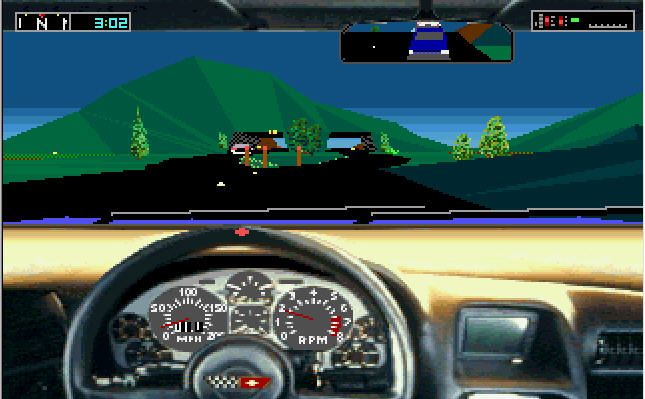
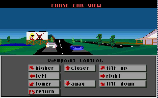
You're right, there are sprites used for trees and brush and MAYBE some of the small guard posts like in the center of the first shot (I couldn't tell from in-game), however the vast majority of the content is in 3D, including the road signs.  For example, the sign and house in the 2nd shot are both in full 3D.  So yes, vegetation would probably look off from a top-down perspective, but I consider this a minor thing since I believe almost everything else would be displayed properly.

Also multiple people are saying "who knows" when regarding the 3D model data; if anyone is inclined, by all means download the game and see for yourself how intelligible it is.  It's abandonware now and I included a link to it in the first post.

10
Hacking the game is unlikely to get you very far, I think. The most likely approach would be to extract the 3D data, but that would be quite hard too, especially without programming or 3D experience.
Well my reasoning is that if someone else was already able to hack the game enough to change how many lives are given to the player, maybe hacking it to change the limit of the tilt angle when in camera mode (shown in the 2nd screenshot) to 90 degrees down might be doable as well.  It's by no means the preferred solution, but anything else requires programming knowledge, which is I'm guessing will be even more unlikely to get.

11
Wow, well that map for the first track is more than I ever found on it.  Even then, there's an incredible amount of details not on it; like farmland patches, sandbars, additional ponds, extensions of some roads / train tracks, a lighthouse, etc.  Thanks for the initial interest, I'm keeping my fingers crossed someone knowledgeable enough will be attracted to this project, even if it is kind of a longshot.

12
I'm very interested in mapping the old game "Test Drive III" released on DOS in 1990.  I think the detail of the level design in what's a fully 3D sandboxed world for 1990 is incredible.  Unfortunately I have no programming knowledge and because the game is in 3D, I can't exactly just stitch screenshots together.  My guess is there is maybe two possible approaches to this:

1. The game includes built-in camera controls that let you fly around to some degree.  This includes a camera tilt up / down function, but it stops at maybe a 45 degree angle each way.  If the executable could be modified so that it could look 90 degrees down, I could stitch together screenshots that way by flying around and taking ground shots.  Changing the .exe is definitely possible, in the version of the game I played, somebody already modified it to have unlimited lives.  This method would be tedious and there would be some inaccuracies due to perspective differences of being in 3D, but it's better than nothing.  I was thinking maybe the program Cheat Engine might be able to assist with this.

2. Since the game is in 3D, find some method of having the whole area rendered at an isometric angle, similar to how I've seen some N64 games here.  This would be the ideal method, but unfortunately this would require programming knowledge and experimentation, I simply don't have the skillset or software to do this.


If anyone out there has ideas on how to accomplish either of these methods or is willing to assist, please let me know. I'm very keen on trying to have this game mapped out.

Abandonware link for the game

Sample Screenshots:


Pages: [1]